
Racine Neighbor Records by Source
Public sources describe parts of a Racine block, but none serves as a complete roster of neighbors. The county parcel layer is best for boundaries and recorded ownership. The tax inquiry adds a dated parcel and payment context. MyVote checks one voter or address at a time, while a formal Badger Voters request can return filtered data under state rules. Racine Neighborhood Watch provides community contacts rather than household records. Choose the source that matches the question, and keep its limits with every result.
| Racine source | Block-level value | Access route |
|---|---|---|
| County tax-parcel layer | Parcel shapes, site addresses, owner fields, zoning, districts, and update date | Public ArcGIS layer |
| City and county property sources | Current parcel facts, mailing fields, assessment, and tax history | City Assessor and county Ascent inquiry |
| MyVote Wisconsin | A single name or address match, plus polling and election information | Individual online lookup |
| Badger Voters | Filtered voter data by municipality, ward, district, election, or date | Paid CSV request through an MFA account |
| Racine Neighborhood Watch | Block-watch, COP House, meeting, and community contacts | Nonprofit office and public website |
A GIS owner field identifies the name indexed to a parcel. It does not show all occupants. Likewise, a postal address is where a notice or tax bill goes, while the site address locates the land. A renter, relative, or other household member may never appear in either field. Neighbor research stays accurate when the record role is stated plainly: parcel owner, mailing contact, registered voter match, recorded deed party, or community contact.
Pinpoint Racine's Target Parcel
Enter the full address and municipality, then confirm the returned Site Address. Save the Parcel Identification Number, PIN12, Building Number, Unit Number, Property Description, subdivision or condominium name, and the layer's Last Update Date. The county service includes a Shape field, which is the mapped polygon needed for true adjacency. A text match alone can select the wrong lot when a number repeats or a unit has its own parcel.
County GIS also records both postal and site addresses. That local quirk is useful, but it can mislead anyone who treats the mailing city or ZIP as the property location. The owner may live away from the parcel. Compare both address fields and label them. The City of Racine Assessor can supply municipal property facts, while county Ascent accepts an owner name, street address, or the last twelve digits of the parcel ID for tax inquiry.
Map Racine Neighbors by Parcel
Once the target polygon is certain, inspect the parcels that share each boundary. A GIS neighbor means adjacency or a chosen distance, not friendship, household membership, or even the same street frontage. Corner lots can meet two streets. Alleys, rights-of-way, waterways, parks, vacant land, and narrow parcel slivers may break what looks like a simple row of lots. Preserve the map shape with the public attributes instead of copying names into a free-standing list.
- Locate the target parcel and confirm its site address, PIN, unit, description, and Shape geometry.
- Read each polygon that touches it, noting the boundary side, adjoining PIN, and any alley, street, or public land between them.
- Copy only the displayed owner and postal fields, along with the layer's update date. Do not relabel owners as occupants.
- Check zoning, assessing neighborhood, tax district, ward, ZIP, and school fields separately because each boundary serves a different purpose.
- Use the Racine street directory when the task expands from immediate parcels to a full named street.
The ArcGIS service supports advanced filters, distance-based spatial queries, pagination, and common export formats. Its maximum record count is 1,000, so a broad extraction may require pages. Most neighbor questions need far less. Keeping the radius small makes the result easier to check and reduces the chance that an unrelated parcel is treated as part of the same block.
The official county parcel layer exposes the fields behind a Racine block lookup.
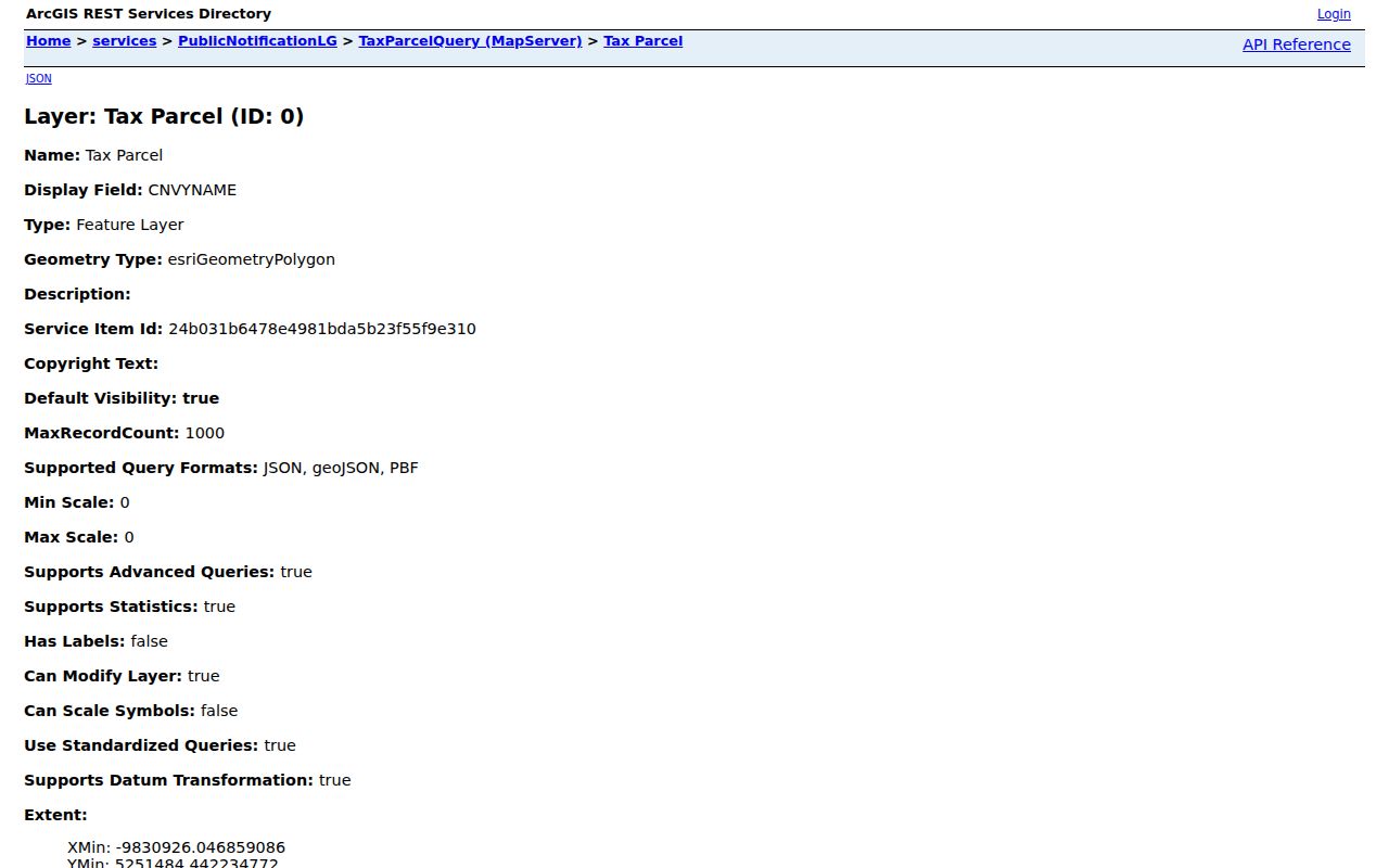
The captured service view confirms that geometry and parcel attributes, rather than a resident list, are the core of the block method.
Racine Neighbors and Voter Data
MyVote Wisconsin is built for a narrow match. Its name search requires first name, last name, and date of birth. Its address form asks for street address, city, and ZIP, with a unit when needed. It may return registration, elections voted, polling information, officials, and ballot details. It does not provide a browsable list of every voter on a Racine block, and a match does not prove that every person at the site is shown.
For aggregate public data, Badger Voters is the documented request channel. It can filter by county, municipality, ward, districts, election, dates, and other options. Output is CSV through a My Wisconsin ID account with multifactor authentication. The price is $25 plus $5 per 1,000 records, rounded, with a $12,500 cap; custom work is $75 per half-hour. Records can include elections voted and poll or absentee history back to 2006. Wisconsin does not track party affiliation.
Use local election staff when an address falls in an unexpected municipality or ward. The Racine County Clerk and City Clerk administer local election records, while the Wisconsin Elections Commission handles MyVote troubleshooting. A narrow open-records request may be used for a nonstandard record, subject to protected fields and the state's balancing test.
Note: A MyVote no-result may reflect spelling, unit, city, date-of-birth, jurisdiction, deceased-status, or confidentiality rules, not absence from Racine.
Community Contacts for Racine Neighbors
Community groups add a layer that property and voter records cannot. Racine Neighborhood Watch is an independent nonprofit founded in 1983 and serves Racine and Mount Pleasant. It supports block watch, apartment and business watch, COP House meetings, mediation, and National Night Out. It is not a government agency and does not publish a verified household directory.
Racine Neighborhood Watch
800 Center Street, Room 316
Racine, WI 53403
262-637-5711
Racine County GIS Routing
Ives Grove, 14200 Washington Avenue
Sturtevant, WI
262-886-8440
No official, complete City of Racine neighborhood-association directory was located in the research. Planning documents name places such as Slausondale, Uptown/Junction, and TowerView within the Greater Uptown area, but a planning polygon is not an association roster. Use these names to understand an area, then ask the nonprofit or city planning staff for the current community contact.
The Racine Neighborhood Watch website shows the local block-watch and meeting model.
The captured page is a route to civic participation and neighborhood help, not a list of who lives at each address.
Racine Neighbor Boundaries Differ
Racine's city GIS includes wards, aldermanic districts, police areas, fire stations, subdivisions, census layers, a grid, ZIP codes, and the city boundary. These overlays are not interchangeable. A ward organizes elections. A ZIP serves mail delivery. A subdivision is a recorded land unit. An assessing neighborhood groups parcels for assessment. A community group may use a name that follows none of those lines.
The distinction matters when two nearby addresses fall into different systems. Use parcel geometry to decide adjacency, then label each overlay by its true role. The county's 1975 addressing study counted at least 105 duplicated street names and 292 duplicate streets, which also warns against using a street name without city, direction, and number. Verify any historic numbering rule before applying it to a current address.
Racine Records Versus Neighbor Tools
Official records and commercial neighbor-search products serve different purposes. A public custodian identifies the source, record date, parcel or request key, access rule, and correction route. Commercial products may merge old addresses, phones, and public extracts without showing when each fact was last checked. They can be a lead, but they should not override the dated Racine record.
| Choice | Strength | Limit |
|---|---|---|
| County GIS and assessor | Parcel geometry, official fields, and update context | Owner data is not a household list |
| MyVote or Badger Voters | Defined election-record fields and official help channels | Protected records and no public block browse |
| Community organization | Current meetings and civic contacts | Not a verified residents roll |
| Commercial category | May suggest another spelling or old address | Can be stale, merged, costly, or poorly sourced |
Protect Racine Neighbors' Privacy
Wisconsin Public Records Law presumes access but requires the custodian to apply statutes, common-law limits, privacy, security, and the public-interest balancing test. Ask for the smallest date range and field set needed. A denial should state its legal basis. Public ownership does not make private utility, delivery, or household information available, and a portal should not be scraped into personal profiles.
Wisconsin Safe at Home gives qualifying people a substitute address and mail forwarding. A confidential elector's actual address is protected from ordinary voter-roll release, and local clerks generally cannot disclose it without the court process stated in law. Do not treat a substitute address as a physical location. A hidden or missing result can be an intentional safety protection.
Lawful use. Use Racine neighbor records for civic contact, property context, reconnecting, or personal safety awareness. Never use them to watch, intimidate, threaten, or harass anyone.
The safest block worksheet stores the target address, parcel keys, adjacent geometry, source date, record role, and community contact without republishing sensitive personal data. When the desired underlying record is not online, contact city GIS, the assessor, county Public Works, the clerk, or the relevant custodian through a focused request.